
High on the windswept plateau of Bleaklow in Northern England's Peak District lies a haunting relic.
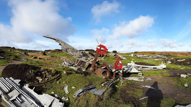
The Bleaklow plane crash site sits frozen in time. A sombre aluminium graveyard where thirteen souls met their end on a foggy morning in 1948.
The Eerie British Plane Crash Site You Can Hike To
Motivated by a love of hiking, rurexing or dark tourism, the site attracts curious visitors from the UK and further afield.
Considering a visit to the Bleaklow crash site? Pack your sturdiest boots and a sense of adventure.
But not before you check out this guide to visiting one of Britain's most eerily fascinating hikes.
By Douglal - Own work, CC BY-SA 4.0, Link
The Tragic Story of the Bleaklow Plane Crash
It was 3rd November 1948 and a foggy morning in England's Peak District.
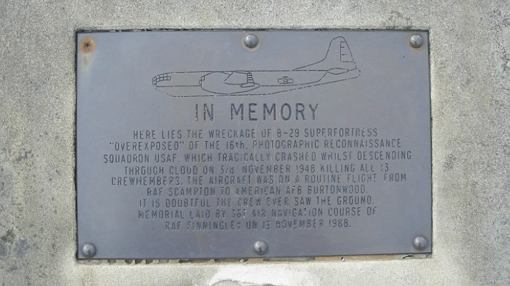
The thirteen crew members of the USAF Boeing RB-29A Superfortress, nicknamed the 'Over Exposed', were on a routine mission.
Starting at RAF Scampton in Lincolnshire, the crew was scheduled to land at RAF Burtonwood in Cheshire.
But sadly, they would never arrive.
Poor weather and low visibility led the crew to miscalculate their altitude.
Believing they had cleared the hills, they began descending, only to collide with Bleaklow Moor at 2,000 feet above sea level.
The impact was catastrophic. All thirteen crew members were killed instantly and the wreckage was scattered across hundreds of metres of remote moorland.
Addshore, CC BY-SA 3.0, via Wikimedia Commons
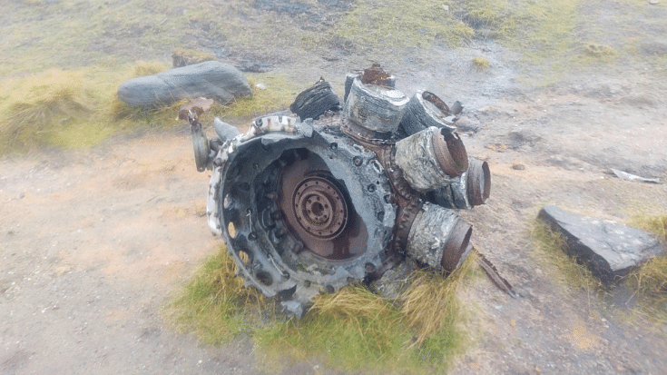
Even today, the scar left on the ground remains visible.
Rescue teams faced brutal conditions and it took days before a full recovery operation could begin.
The disaster became known as the Bleaklow plane crash. A tragedy frozen in the windswept wilderness of the Peak District.
Frozen in Time - The Bleaklow Crash Site Today
Today, 77 years later, the wreckage still lies scattered across the unforgiving moorland.
It's a haunting, sobering sight, drawing in those who are strangely captivated by its tragic history.
Due to the remote and challenging nature of the site, the British government never cleared it.
What remains is a chilling, accidental memorial, a time capsule frozen in tragedy.
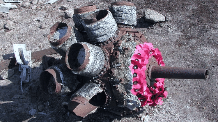
Twisted shards of aluminium, broken engine parts and fragments of landing gear lie across the landscape. All slowly being reclaimed by nature.
Geotek at en.wikipedia, Public domain, via Wikimedia Commons
A proper memorial stands at the site - a simple stone with a plaque listing the names of the thirteen who perished.
Visitors often leave poppies, flags and tributes.
By Andy Beecroft, CC BY-SA 2.0, Link
Rur-exing and Dark Tourism - The Bleaklow Plane Crash Walk
In 2025, the site draws adventurous Brits and international travellers interested in dark tourism and rurexing - i.e., rural urbexing.
The Bleaklow crash site provides this in abundance. It's raw, unpackaged and uncommercialised. There's no gift shop or café - just wreckage, wilderness and weather.
Its authenticity may be why it continues to draw curious visitors. In a world of curated experiences and Instagram perfection, the stark reality of the crash site is a rare experience.
People may also visit to explore the wider area. Interestingly, several other air crashes have occurred here before and since.
Getting to the Bleaklow B-29 Crash Site
There are several ways to reach the Bleaklow bomber crash site, each with varying degrees of difficulty. Two of the more popular routes are as follows.
On Public Transport From Glossop
If you don't drive or have a car, not to worry. It's still possible to reach the Bleaklow crash site using public transport.
Travel to Glossop and from there, make a day of it with an 11-mile/17 km circular route through the moorland.
It should take roughly six hours to complete.
Sure, it's a long day. But the satisfaction of completing a challenging walk, twinned with the sweeping drama of the Peaks will ease the muscle ache.
By Car From Snake's Pass
If you're planning to visit by car, you can park at this spot right at the mouth of the Pennine Way path, which will take you onto the route.
Tip: This small parking spot becomes crowded, especially on weekends and bank holidays. So, making an early start is a good idea.
Once you've parked up and grabbed your flask and sandwiches, follow your map to the Bleaklow plane crash walk route.
Walking Maps for the Bleaklow Crash Site Walk

Adobe Free Stock / LoloStock
There are lots of reliable maps available to help you hike the Bleaklow plane crash walk. Here are just a few.
- Peak District Walks sells a downloadable PDF map of a six-mile/9.6 km Higher Shelf Stones Circular Walk.
- Komoot has a collection of walking routes in the Bleaklow area. Maps can be downloaded so you can access them when offline.
- AllTrails also has a variety of maps available that take in the Bleaklow bomber crash site.
- Ordnance Survey has a dedicated paper map for the Dark Peak and Bleaklow areas available to buy online.
Important!: You will need a copy of whatever map you use to be available offline for the whole duration of your walk.
Maps relying on an internet connection are likely to fail you along the way.
Know Before You Go - The Bleaklow Plane Crash Walk
"Due to the exposed nature of the crash site location and distance from parking areas, please be aware that weather conditions can change dramatically, even in summer." - Peak District National Park Authority.
Its remote location and the fact it's a memorial site mean it's worth some consideration ahead of your hike. Here are some things to know before you go.
- The site is guarded under the Protection of Military Remains Act. This means it's not only unadvisable, but illegal to disturb or remove anything, conduct unauthorised excavations or explorations.
- Notorious for changeable weather, conditions on your way to the Bleaklow crash site can completely shift at the drop of a hat.
- Layer up in expectation of weather extremes - both cold and warm.
- As well as the weather, the terrain is challenging. It can be boggy in places, rocky in others and involve some road-walking.
- Come with awareness of the day's weather forecast and maybe a weather app.
- Take plenty of water and some nutrient-dense non-perishable food to sustain you in case of emergencies.
Stay Online with an eSIM from Airalo
Before setting off to explore the eerie Bleaklow plane crash site, make sure you're prepared for whatever this challenging hike might throw at you. Including dealing with patchy internet coverage.
An eSIM from Airalo can ensure you have the best chance of staying online in remote locations while staying in control of costs and saying no to ridiculous roaming fees.
Just head to the Airalo store, choose the eSIM you need for your location and install.
Now all you have to worry about is the minor business of getting there and back in one piece. Happy hiking!


